Difference between revisions of "File:Midde-Seas-Distance-Chart.gif"
From Woldipedia
(This is a table showing travel distances by ship to and from common destinations around the Middle Seas of Yrth, and points east.) |
(Cayzle uploaded a new version of "File:Midde-Seas-Distance-Chart.gif") |
(No difference)
| |
Latest revision as of 14:57, 16 March 2017
This is a table showing travel distances by ship to and from common destinations around the Middle Seas of Yrth, and points east.
File history
Click on a date/time to view the file as it appeared at that time.
| Date/Time | Thumbnail | Dimensions | User | Comment | |
|---|---|---|---|---|---|
| current | 14:57, 16 March 2017 | 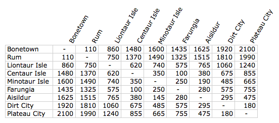 | 552 × 244 (21 KB) | Cayzle (Talk | contribs) | Update to the original chart that fixes a dumb typo. |
| 19:43, 8 April 2012 |  | 552 × 244 (21 KB) | Cayzle (Talk | contribs) | This is a table showing travel distances by ship to and from common destinations around the Middle Seas of Yrth, and points east. |
- You cannot overwrite this file.
File usage
The following 2 pages link to this file:
